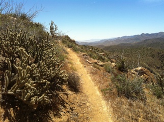
On To The Mountains

20110619-072131.jpg

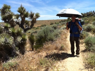
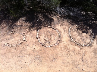
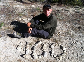
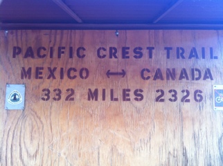
Late this afternoon, after hiking 25 miles, I passed a milestone of sorts: Since I’ve walked 676 miles, I now have less than 2,000 to go. Dang, this trail is long!

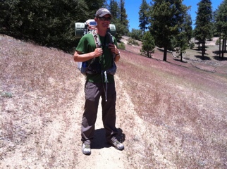
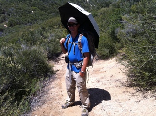
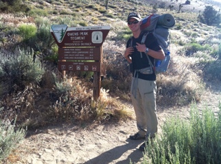
My mom said goodbye this morning after more than a week of meeting me at different points along the trail. It’s been so nice to have the company and lighter load in various sections; I miss it already. She’s on her way back home to Oregon, and I’m on my way to Kennedy Meadows, gateway to the Sierras. I might even get there tomorrow…

Walker Pass Magic

20110618-045154.jpg

I shuffled into Walker Pass this afternoon, after a 20-mile day, to the unexpected sound of coordinated applause. A large canopy had been erected at the edge of the otherwise desolate campground, with two dozen grinning faces peering out of the shade – and I was immediately offered my choice of iced beer or soda, to be followed later by a full-on dinner!

A couple of generous trail angels have been running this spot continuously for the last week, greeting each hiker who hits the end of Section F with the equivalent of a marathon aid station or racecar pit stop, scaled to PCT standards. Quite a nice surprise after the desert, though it was cool to get my first views of snow-capped Sierra peaks in the distance this morning. Weird to think I’ll be up in them next week.

Sand, Sun, Rocks… Repeat

20110617-051252.jpg

Yesterday’s cool mountains were just a tease; today the trail plunged right back into the Mojave furnace, and I spent 23 miles slogging through pea-gravel sand without shade besides the occasional Joshua Tree or flyover fighter jet.

I crawled under a Joshua for two hours in mid-afternoon, and quickly discovered its soft-looking leaves might as well be bristling steak knives, drawing blood wherever they poked. It sure gave me extra appreciation for the Loggerhead Shrike nest I found in a Joshua Tree earlier in the day, holding two well-protected nestlings. How the birds manage not to skewer their eyes out, I’ll never understand.

I should hit Kennedy Meadows on June 22nd, where the desert officially ends and the Sierras begin, at mile 700. Bring on the snow – I’m ready for it.

600

20110617-045921.jpg

I passed the 600 mile mark this afternoon on my way into the wonderfully cool, green Tehachapi mountains, full of pines and oaks – a nice respite from hot desert.

One of the highlights of my 20.7-mile day was spooking a deer: a real, live, actual specimen of wildlife! Yes, I see them every day at home in Oregon, but this was the first animal bigger than a rabbit I’d encountered on this whole trip so far. I also found cougar tracks on the trail today, and met two different hikers who’d seen bears recently, so maybe I’ll run across one of those, too.

Desert Sunshine

20110616-102825.jpg

Early this morning, on an exposed 2,000-foot climb outside Tehachapi, I met a group of three PCT hikers heading south. Uh, south?

“We walked north up this trail yesterday,” one guy explained, “and it was just way too hot. We were all getting serious heat exhaustion.” They all nodded, and another guy added, “My thermometer said 113 degrees. It was crazy.” When they nearly ran out of water, and one of them started vomiting, they had decided to turn around, backtrack 10 miles to the last highway crossing, hitchhike to “the beach,” and take a few days off before skipping north 150 miles to the Sierras, with vague plans to make up the missing desert section in a cooler month.

It sounded like a rough time, but I pushed ahead and encountered no such difficulties. My thermometer registered 85 this afternoon, exactly the same as yesterday, and I only needed two of the four liters of water I packed despite 20 miles with only one water source. Hope those guys enjoy the beach, anyway…

Nero

20110614-074047.jpg

After 12 consecutive 20+ mile days, Tehachapi sucked me into the vortex known as Best Western, so, instead of sleeping in my tent 20 miles up the trail tonight, I’m watching Valentine’s Day on TV and lounging on a crisp set of sheets while eating fresh strawberries.

It wasn’t a total loss; my mom helped me slackpack an eight-mile section through a wind farm this morning, which took about three hours, qualifying today as a “nero” (the hiker term for “nearly zero”). Then it was all about enjoying civilization; we even went to a movie! The only film showing in Tehachapi this afternoon was Kung Fu Panda 2, and the theater was jammed with little kids, but it was dark, cool, and full of popcorn – awesome. Tomorrow, back to the trail with fresh legs.

Tehachapi

20110613-085042.jpg

After a long, grinding uphill out of the Mojave desert, I spent the afternoon traversing along a shadeless ridge until it dipped toward Tehachapi in a valley full of hundreds of giant windmills. The turbines sprouted from bare hilltops like a forest of enchanted trees – quite a spectacle after endless miles of desert.

Today was my second marathon-distance day of the trip, at 26.4 miles, and maybe the hottest day so far without much shelter besides my reflective umbrella. Only a few more days before I’m done with the desert for good…

The L.A. Aqueduct

20110612-051925.jpg

What a weird day. At about 9 am I stopped at Hikertown, the home of a guy named Bob who has converted his 3-car garage into a veritable PCT oasis, with separate bathroom and lounge areas, and who hosts several hundred hikers each year. He’s also built a small-scale Western town in his front yard, and occasionally ferries hikers to a nearby restaurant in his old Rolls Royce.

Tempting, but I wanted to get today’s miles in before the heat hit. Decades ago, owners of the massive Tejon Ranch refused to allow PCT builders to route the trail through their mountains, so this section takes a 22-mile detour straight through the edge of the Mojave desert, following a barren dirt road along the Los Angeles Aqueduct (ironically, the structure is mostly enclosed, with no access to water for the last 15 miles). This is a notoriously hot, flat, and desolate stretch; the average high on June 12, based on the last 30 years, is over 100 degrees; so I was lucky to cross today on a lovely 85-degree afternoon, with a breeze. And now, with this section out of the way, I can start praying for heat: I’ll hit the high Sierras in about a week!

500

20110612-092037.jpg

I put in a solid 11×10 (11 miles by 10 am) in the cool morning hours, then spent the rest of the day meandering along an oak-lined ridge in the Angeles National Forest, for a total of 25.3 miles today.

Just before midday I hit the 500-mile mark, spelled out in rocks on the side of the trail. Someone has taken the time to arrange similar “milestones” every 100 miles so far, so I look forward to every hundred completed. Half a thousand miles already! That’s farther, for instance, than the whole length of Oregon, but still less than a third of California…

Chaparral

20110610-045336.jpg

I felt like a pawn advancing down a chess board today: just moving forward. The trail wound through homogeneous chaparral for 20.1 miles, mostly shadeless and dry, up and over a couple of thousand-foot ridges, gradually heading north.

But I stumbled over a family of baby Mountain Quail, flushed a Turkey Vulture off a dead skunk on the trail, and met two Israelis named Pepper and Mace who had just taken seven days off for no particular reason (guys, we still have a long way to go…), so I didn’t get too bored. And I was glad to hike under my reflective umbrella for most of the afternoon, perfect for these hot, sunny desert sections.

Agua Dulce

20110609-054552.jpg

Today was punctuated by an unusual number of different and interesting landmarks, making 21.4 miles go fast. First I crossed under I-14 via a long, mine-shaft-like tunnel; then passed through Vasquez Rocks; and finally walked through Agua Dulce, a tiny town full of interesting distractions including a large sign advertising a “Lost Monkey.”

I’m back in the desert foothills, with temperatures in the low 80s this week. It’s fun to see some birds I don’t often encounter; today’s list included Phainopepla, Rufous-crowned Sparrow, California Thrasher, Costa’s Hummingbird, and Nuttall’s Woodpecker. Sure ain’t in Oregon yet!

Slackpacking

20110608-082243.jpg

My mom is meeting me at trailheads and road crossings this week, which means I can carry a lighter pack and sleep in civilization more often. Last night we stayed at a motel in Palmdale, and tonight I was able to reach a KOA Campground via a stark, 25-mile stretch of burned-over trail charred by the disastrous Station Fire a couple summers ago.

Backpacking without carrying a fully-loaded pack, partly supported by outside help, is called “slackpacking,” and most long-distance hikers jump at any chance. It’s not often that someone volunteers to literally take weight off your back, and I’m grateful to my mom for the support this week. When we walked into the KOA oasis together this evening in pristine low-angled sunlight, after flushing a Great Horned Owl around the last bend (closely pursued by a Hooded Oriole), thinking of SPAM and chili for dinner, I really couldn’t have been much happier.

20 Days, 400+ Miles

20110607-061918.jpg

Day 20, and pleased to report that I am healthy and happy. So far, I’ve walked 419 miles with no days off; my longest day has been 27.4 and my shortest 12.9, averaging about 21 miles per day.

I’m grateful to have escaped injury so far, as already three different hikers I’ve met have quit the trail in disappointment. I haven’t been sick, taken a single Ibuprofen, or even set an alarm to wake up. The weather has been almost perfect. If every day could be like today, a smooth 21 miles through interesting terrain, this would almost be too easy!

In two weeks, though, I’ll hit the high Sierras, and early reports are suggesting an incredible amount of snow there. Anyway, that’s still 300 miles away…

On Thick Ice

20110606-092841.jpg

I began the day by climbing straight up Mount Baden-Powell, and was on the 9300-foot peak by 9:30. It was subfreezing up there, with two inches of solid ice on the windward side of all surfaces; the last half mile before the summit led over continuous frozen snowdrifts; and my tennis shoes didn’t give much traction on the ice, so I was happy enough to safely descend the west ridge after a chilly ten minutes on top.

The rest of the day was spent leapfrogging across highway two in dramatic mountain terrain. I was forced to take a five-mile detour around one section of trail closed to protect endangered Mountain Yellow-legged Frogs (what, do they think hikers are going to boot them into extinction?). Overall 24 miles, and some fantastic scenery today!

Wrightwood

20110605-081941.jpg

Last night we couldn’t find a good campsite, so Toby, Natalie, Brian and I rolled our sleeping pads out right on the trail without putting up tents. “Cowboy camping” like this has merits – sleeping under the night sky is pretty cool – but I woke up this morning covered in cold dew, motivating my earliest start yet at 6 am.

I spent most of the day hiking alone, slowly gaining elevation toward Mount Baden-Powell, a 9400-foot peak which I’ll ascend tomorrow morning. In late afternoon I met my mom, who had just driven from Oregon to spend the next week meeting me at different places along the trail. After a 24-mile day, it was sure nice to be ferried to a motel room in Wrightwood without even having to hitchhike!

McMecca Meal

20110604-090519.jpg

The McDonald’s along I-15 at Cajon Pass, east of L.A., is famous among PCT hikers because of its proximity to the trail, air conditioning, and delicious delights. After 15 dusty miles by noon, the golden arches were looking pretty enticing, and I went all-out in true hiker style.

The cool part was that the calorie counts are right on the quick-order menu, so you can plan for maximum energetic intake. I started with two crispy chicken burgers (2 x 600) and followed up with a Reese’s McFlurry (400), then an Oreo McFlurry (400), and finally a large chocolate shake (850), for a total of 2850 calories in one sitting! Good fuel for a solid 26-mile day today, but it’s hard to keep up with an insatiable appetite; by dinner I was glad to have also thrown a 12-inch Subway sandwich into my food bag – yum.

Loons And Grebes

20110603-071708.jpg

Brian, Natalie, Toby and I, having laughingly dubbed ourselves The Wolf Pack, walked 26 miles today, spurred on by the promise of lunch at McDonald’s, Subway, and Del Taco (simultaneously) at Cajon Pass tomorrow.

We’re camped near the scenic Silverwood Lake tonight, east of L.A., which gives me a chance to add some waterbirds to my trip list. So far I’ve seen about 100 species, the most unusual probably a Black Swift over the chaparral near Mexico, but am missing waterbirds in general. A Clark’s Grebe and Common Loon were nice addition just now around sunset.

300 Miles Down

20110603-125651.jpg

I’ve caught up to a small group of hikers, so it’s been a few days since I spent any time alone – a nice change. Today I walked with Brian and a young couple named Toby and Natalie for a pleasant 22 miles, gently descending from the San Bernardino Mountains back into desert foothills, past mile 300.

Near the end of the day we hit Deep Creek, the most flowing water I’ve yet encountered. Unfortunately, severe storms damaged the trail in this section last December, closing the trail, and apparently a guy died recently after falling over a cliff in the off-limits section. So, instead of following the creek for the next 15 miles, we’re taking the official detour on roads and ATV tracks, and camping tonight on a dusty roadside pullout, next to a barbed wire fence.

Lost and Found

20110601-080753.jpg

This morning I ordered “The Mess” at a trendy breakfast cafe in Big Bear City – which turned out to be a heaping plate of eggs, hash browns, meaty stuff, veggies, and just about everything else a hungry hiker could ever wish for.

Then Brian and I managed to hitch a ride to the post office, where we retrieved resupply packages and had our photos taken for a big PCT board on the wall, and finally headed back to the trail, putting in 13 miles despite a 12:30 start and full stomachs. Best of all, though, we ran into Adam, who I camped with three nights last week. He had discovered my lost umbrella near Mt. San Jacinto and handed it over, saying “I’m glad I finally caught you. I’ve been carrying this thing for the last three days!”

Tonight I’m camped with Brian and two other hikers, Toby and Natalie, on a ridge overlooking Big Bear Lake. It’s about 33 degrees, but nice to have some company up here.

Lions, Tigers, and Bears

20110531-110103.jpg

This morning I calculated it would be possible to reach Big Bear City, my next resupply point, via a 28-mile hike to Highway 18 and a subsequent 4.5-mile hitchhike into town. All right – civilization!

I caught up to another hiker named Brian in late morning, but not before taking in a bizarre sight. Right beside the trail, around mile 248, were a series of reinforced cages with serious predators inside: a lion, Bengal tiger, and two grizzly bears. And I thought we didn’t have to worry about bears until the Sierras, in another 500 miles! Turned out they were trained for the movies.

Brian and I kept up a good pace despite an unexpected cache of soda, bananas, and cookies in coolers by the trail, left for PCT hikers. After hiking 28 miles, we hitched into town with a kindly plumbing contractor, ate an enormous dinner, and checked into a hostel after a very long day.

Up A Creek

20110531-103257.jpg

It was an uphill battle today as I climbed 5,000 feet (a vertical mile) into the San Bernardino Wilderness, following an idyllic Mission Creek through an endless gorge lined with cottonwoods, with pines at the upper end. I caught up to another hiker named Todd in late morning and we leapfrogged each other for the rest of the afternoon, then camped together while he told me stories about owning a landscaping business.

I also saw my second rattlesnake this afternoon, rattling and coiled in strike pose on the side of the trail. And it was good to make another 22.5 miles today, especially all uphill!

One Mountain To Another

20110531-114036.jpg

After another rough morning breaking camp in extreme wind high on Fuller Ridge, this time with a cold mist thrown in, I fled down the trail in search of warmer climes. And down it went – 15 miles of continuous switchbacks dropped 6,000 feet, all the way to San Gorgonio Pass and the lowest point on the California section of the Pacific Crest Trail. Easy walking except for a thick, brushy, burned-over area, where apparently my umbrella got ripped off my pack without me realizing it – bummer.

In the afternoon I crossed four-lane Interstate 10 and found three coolers underneath the overpass with ice, drinks, and fresh fruit for PCT hikers. Then it was on up into the San Gorgonio Mountains, past a couple miles of scenic windmills, to my camp in a little canyon. Altogether 24.3 miles today, my longest yet!

Wind And Snowdrifts

20110528-085255.jpg

40 mph winds had me wide awake at 3am this morning, and by dawn had scattered my stuff all over my campsite – even my pack had been blown 30 feet from where I set it down. Tonight is no different; if anything, the wind is even stronger!

I spent the day hauling myself over the flank of Mount San Jacinto, at one point over 9000 feet, with a side trip down to the small town of Idyllwild to get some more food. Lots of small snowdrifts up there, but nothing scary. Overall 21.1 miles today (but only 15 of them on the PCT). Tomorrow I’ll drop more than 6000 feet back to the desert; my knees can’t wait!

Up And Up

20110528-025330.jpg

I started the morning in desert chaparral at 4900′ and ended near snowdrifts at 8250′. Add in an extra couple thousand feet up and down, including a bonus two miles down a spur trail to get water, and I ended up hiking 25.7 miles with about five thousand feet of elevation gain today – yikes!

Even if the trail was steep in places, the scenery surpassed anything I’ve seen so far. After 150 miles through the desert, I was psyched to climb up into the San Jacinto Wilderness with its shaded slopes of pine and fir stands, and cliffs so sheer the trail had to be blasted out of solid rock in some sections. As evening approached, I wound up a dramatic ridgeline, leapfrogging with a couple other hikers, looking down on Palm Springs as if from an airplane. Very cool.

Paradise

20110526-055537.jpg

After some quick calculations this morning, I realized it would be possible to make it to a famed burger joint, the Paradise Cafe, just in time for dinner. It took a 25-mile day through the desert, including 2 miles off-trail, but I just arrived along with another hiker, Adam, who has been keeping pace the last couple days. A root beer float tastes awesome after 25 miles in the sun, and the burger is ordered!

It looks like the next couple days will be spent at higher elevation, so maybe I’ll get a change of scenery. And maybe I’ll at last get out of the wind; it was really whipping all day today. Anyway, 150 miles down!